• Features
  • Videos
  • Podcasts
  • Specials
  • Articles
  • Shorts
Donate
  • English
  • Español (Spanish)
  • Français (French)
  • Bahasa Indonesia (Indonesian)
  • Brasil (Portuguese)
  • India (English)
  • हिंदी (Hindi)
  • বাংলা (Bengali)
  • Swahili
  • Videos
  • Podcasts
  • Articles
  • Short News
  • Feature Stories
  • The Latest
  • Explore All
  • About
  • Team
  • Contact
  • Donate
  • Subscribe page
  • Submissions
  • Privacy Policy
  • Terms of Use
  • Advertising
  • Wild Madagascar
  • For Kids
  • Mongabay.org
  • Reforestation App
  • Planetary Health Check
  • Conservation Effectiveness
  • Mongabay Data Studio

A search engine for the planet opens to the public

Rhett Ayers Butler 28 Apr 2026
The idea that the Earth can be “searched” like a database has circulated for several years in academic and technical circles. Earth Index, developed by the nonprofit Earth Genome, brings that idea into practical use. Earth Index allows users to scan satellite imagery by visual similarity. A user can highlight an example—a patch of deforestation, a mining site, a trawler, or an airstrip—and instruct the system to find comparable patterns elsewhere. The underlying approach relies on “foundation models” trained on vast archives of Earth observation data, enabling the system to recognize features across geography and time. Until recently, such analysis required specialized teams, bespoke models, and significant computing resources. Even well-funded investigations could take months to develop. Tools like Earth Index reduce that burden. In one Mongabay-specific case, our journalists used it to identify previously unreported narcotrafficking airstrips in the Peruvian Amazon, combining automated detection with on-the-ground reporting (Spanish) Earth Index is now available without a waitlist, through an “Open” tier that provides global access and core features to any user. More advanced capabilities—such as higher usage limits, API access, and a more computationally intensive “Deep Search”—sit behind a separate tier, though the developers say they intend to keep access free for high-impact users. This expansion reflects a shift in how geospatial AI is being deployed. Satellite data has been publicly available for decades, yet much of it remains underused because of its complexity. Foundation models alter that dynamic by allowing users to interact with imagery in more intuitive ways, translating raw pixels into searchable patterns. Earth Index’s design emphasizes accessibility. Non-technical users can upload their own reference data, generate training labels, and share results publicly. The system supports iterative workflows in which human judgment refines machine output, enabling datasets that once took months to assemble to be built in days. [caption id="attachment_318313" align="alignnone" width="1200"]Amazon-Mining-Watch Earth Genome worked with Amazon Conservation and Pulitzer Center to build Amazon Mining Watch.[/caption] Early applications suggest a wide range of uses. Investigations have mapped illegal gold mining in the Amazon, quarry operations in the Balkans, watersheds in California’s farming heartland, and methane emissions from cattle. Others have used the tool to catalogue industrial livestock facilities or track changes in land use across regions. Much of the underlying imagery comes from public satellites with moderate resolution and update frequency, making the system less suited to real-time monitoring. Interpretation still depends on user judgment, and false positives remain a risk. The availability of such tools also raises questions about oversight and misuse, even if current data constraints reduce the likelihood of surveillance at a granular level. Its main impact, for now, is that access extends beyond specialists. By lowering the technical threshold, it extends capabilities once confined to governments and specialists to a wider set of actors: journalists, researchers, advocacy groups, and local communities. Whether it improves environmental outcomes will depend on who uses it, and to what ends. Disclosure: Mongabay has a partnership with Earth Genome. Earth Genome did not have editorial influence over this piece.
Amazon Mining Watch leverages artificial intelligence to map the impact of gold mining activities across all nine Amazonian countries.

Counting bats in the dark

Sam Lee 4 Mar 2026
How do you count and keep track of bats? Advances in videography, including thermal cameras, have made it easier to spot bats. But these animals move fast, travel in big groups and are often found in the dark — making analysis of the data a tough task. Scientists have developed a new software called Thrutracker Analytics that uses traditional computer vision and artificial intelligence to count bats. Watch the latest episode of Then vs Now to learn

Flying along with monarch butterflies

Abhishyant Kidangoor 24 Feb 2026
Every year, monarch butterflies make their iconic migration across North America. The journey spans thousands of miles and three countries. However, very little is known about this migration, resulting in the lack of concrete data about a very important life stage of these butterflies. Scientists are now using lightweight radio tags to get insights into the mysterious migration of monarch butterflies. Using the technology, they have been able to understand how and where the butterflies move, filling crucial gaps in the data. Watch the latest episode of Then vs Now to learn more.
Monarch Butterfly

Snooping on stingrays

Abhishyant Kidangoor 15 Feb 2026
Biologging trackers have long been used to track and monitor marine animals like whales, sharks and dolphins. But it has been a challenge to use them on stingrays because of their smooth skin and the lack of a prominent fin. Scientists have now developed a multisensor tag which can be securely attached to sting rays. The tags gather a wide array of data including how the animals move, how they interact with other species and move through their habitats. Watch the latest episode of Then vs Now to learn more.
Stingray

How rain can reveal what lives in rainforest treetops

Rhett Ayers Butler 20 Aug 2025
Founders briefs box Perched high above the forest floor, the tropical canopy is a reservoir of biodiversity that has long resisted scrutiny. Its inaccessibility has left many of its inhabitants — orchids, epiphytes, ants, monkeys, frogs — poorly studied and poorly protected. But a new study offers a workaround: let the rain do the climbing. Scientists led by Lucie Zinger at the France-based Center for Biodiversity and Environmental Research (CBRE) have shown that water dripping from the canopy carries traces of DNA, or environmental DNA (eDNA), from the organisms above. By capturing and analyzing this “rainwash” in low-tech collectors, they identified hundreds of species across plants, insects, birds, amphibians, and mammals. The plants and animals detected in rainwash of an old-growth forest compared to a plantation plot. The study, conducted in French Guiana, compared samples from a mature Amazonian forest and a nearby tree plantation. The results were striking. Diversity was markedly higher in the undisturbed forest, where passive collectors accumulated eDNA over a 10-day period. Crucially, the rainwash signal was both local and persistent. Even after heavy rain, biodiversity signatures remained spatially distinct at the scale of tens of meters and stable for up to 40 days. Unlike airborne or stream-based eDNA, which can drift and muddle geographic origin, rainwash captures a sharp snapshot of the immediate canopy. It can also be deployed at scale with minimal cost. The researchers propose that this method could become a cornerstone of biodiversity monitoring in tropical forests — habitats that are increasingly threatened and chronically undersurveyed. That’s not to say it’s a panacea. Detection remains limited to species that shed detectable DNA, and to wet seasons when rainfall is sufficient. But in a field stymied by logistical and financial constraints, the ability to “listen” to the canopy through its own runoff is a conceptual advance. In the future, the hum of the rainforest may be traced not through what can be seen and heard, but through what the rain leaves behind. 
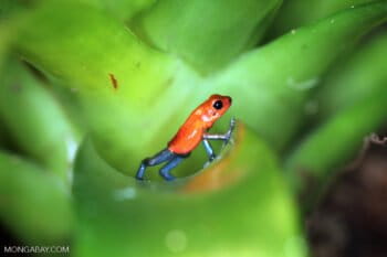
Banner image of a strawberry poison dart frog, by Rhett A. Butler/Mongabay.  

Drone swarms and AI take aim at stopping wildfires in 10 minutes

Mongabay.com 31 Jul 2025
Fifteen teams have advanced to the semifinal round of XPRIZE’s $5 million Autonomous Wildfire Response Track, moving one step closer to proving that autonomous systems can detect and extinguish wildfires within 10 minutes across 1,000 square kilometers of challenging terrain. Part of a four-year, $11 million global competition launched in 2023, the initiative seeks to spur breakthroughs in rapid-response firefighting technology as climate-driven wildfires grow more frequent and destructive. Selected from a global pool, these teams represent a range of institutions, from defense contractors to university research labs and even a high school in California. Each presents a unique solution that blends robotics, artificial intelligence, and wildfire science. “The convergence of exponential technologies such as AI, robotics, drones, and sensors offers us the opportunity to detect wildfires at inception, and put them out in minutes before they spread—that’s the mission of this XPRIZE,” said Peter H. Diamandis, Executive Chairman of XPRIZE, at the time of the competition’s launch in 2023. Many of the semifinalists take a “system-of-systems” approach. AeroWatch, a Spain-based consortium, is integrating components from over a dozen partners to create a unified interface for fire managers. Crossfire, based at the University of Maryland, deploys scout UAVs for surveillance and “Firejumper” drones for suppression. Its system was validated in a live-fire demonstration earlier this year. Others focus on scale and speed. Canada’s FireSwarm Solutions is developing heavy-lift drone swarms capable of operating at night. Germany’s Dryad combines solar-powered sensors with reconnaissance and suppression UAVs to detect fires at the smoldering stage. Meanwhile, Anduril, a U.S. defense tech firm founded by Oculus VR’s Palmer Luckey, is fielding its AI-enabled Lattice OS platform paired with advanced sensor towers and aerial reconnaissance. Student-led teams are also in the mix. Wildfire Quest, from Valley Christian High School in San Jose, has built a solar-powered, self-replenishing drone system with an expandable suppression network. RAINDROPS, a collaboration between Norwegian and American universities, is piloting a low-cost system-of-systems architecture designed for global scalability. This summer, the XPRIZE Wildfire team will visit each semifinalist’s test site to evaluate the systems in live field conditions. These trials will assess technical readiness, safety, connectivity, and resilience in real-world settings, including high heat, wind, and complex terrain. The Alaska Center for Unmanned Aircraft Systems Integration will oversee data capture for judging. The stakes are high. According to XPRIZE, Extreme Wildfire Events now account for over 80% of fire-related damages worldwide. “With over 30 years of experience in fire management, I’ve seen firsthand how devastating wildfires can be,” said Shawna Legarza, former director of fire and aviation at the USDA Forest Service, in the 2023 launch statement. “To better protect our land and ourselves, we need to change the way we detect and manage wildfires now.”
Krasnoyarsk, Siberia, is just one region where fires are burned throughout Russia in 2020. Image by Greenpeace International.

World Nature Conservation Day: How a large, flightless parrot rebounded from the verge of extinction

Rhett Ayers Butler 28 Jul 2025

Founder's Briefs: An occasional series where Mongabay founder Rhett Ayers Butler shares analysis, perspectives and story summaries.

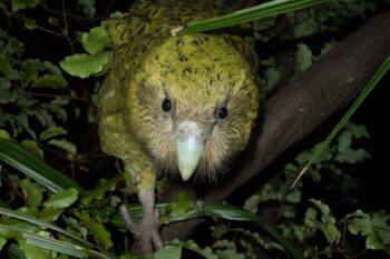
In the mid-1990s, the kākāpō seemed destined for extinction. Only 51 individuals of the flightless, nocturnal parrot remained, all of them descended from a shrinking gene pool and spread across remote corners of New Zealand. A victim of its own evolutionary success, the kākāpō had once flourished in a predator-free island ecosystem. But its defenses—freezing when threatened, nesting on the ground, and producing a strong scent—proved fatal once humans introduced cats, rats, and stoats. Against these odds, the kākāpō recovery has become one of conservation’s most carefully managed comebacks. The entire population is now named, monitored, and fitted with smart transmitters. Breeding, which occurs only during occasional mast years when native trees fruit heavily, is bolstered by artificial insemination and precision feeding. Drones ferry sperm across island sanctuaries in minutes, shortening a journey that once took hours on foot. Data loggers track every movement, weight change, and mating. The results are cautiously encouraging. As of 2024, the known population stands at 244 individuals. All reside on predator-free islands, with a few reintroduced to the New Zealand mainland under close surveillance. Scientists have even sequenced the genome of every adult kākāpō, using genetic data to manage breeding pairs and reduce the risks of inbreeding. Success remains fragile. The species is still critically endangered, and low genetic diversity continues to affect fertility. Yet the recovery offers valuable lessons for other conservation efforts. The kākāpō’s survival is a testament to long-term planning, technological innovation, and sheer persistence. What began as a desperate salvage mission has become a case study in high-stakes species management. Lessons from the kākāpō recovery:
  • Technology scales conservation: Smart transmitters, automated feeders, and drones allow for real-time, individualized care across remote terrain.
  • Genetics matter: Sequencing every bird helps mitigate inbreeding risks and improves mate selection in small populations.
  • Predator control is essential: Removing invasive mammals remains the foundation of any island-based recovery program.
  • Breeding requires precision: Artificial insemination and targeted nutrition can enhance reproductive outcomes, even in reluctant breeders.
  • Persistence pays off: The kākāpō’s recovery has taken decades, demanding patience, trial and error, and sustained funding.
Few species have fallen so far and clawed back so much. The kākāpō still cannot fly—but extinction is no longer its only trajectory. Header image: An adult female kākāpō. Image by Andrew Digby/New Zealand Department of Conservation.
An adult female kākāpō (Strigops habroptila) in a tree at night. Kākāpō are nocturnal and flightless. Image by Andrew Digby/New Zealand Department of Conservation.

Subscribe

Stay informed with news and inspiration from nature’s frontline.
Newsletter

Scat-sampling DNA tool shows potential in African carnivore conservation

Dann Okoth 19 May 2025
Researchers have developed a noninvasive DNA tool to help monitor hard-to-trace African carnivores, including caracals and leopards, making it potentially useful in the conservation of elusive and increasingly threatened species. “Carnivores are really difficult to study/observe in the wild, and even if a fecal sample is found, it is often difficult to determine which species it comes from,” Anne Schmidt-Küntzel, a co-author of a new study detailing the tool, and director of animal health and research at the Namibia-based Cheetah Conservation Fund (CCF), told Mongabay in an email. Researchers analyzed DNA material in fecal samples from wild carnivores in Southern Africa to identify a specific genetic marker, called a “mini-barcode,” that can be used to determine the species it came from. “Using the marker allows us to find out which species was present in the study area,” Schmidt-Küntzel added. The researchers collected 157 samples to analyze, and compared their results with known data collected in Namibia 13 years earlier. They were able to successfully identify the carnivores nearly 95% of the time, finding six different species, including leopards (Panthera pardus) and caracals (Caracal caracal). The researchers suggest the marker could also be a useful monitoring tool for lions (Panthera leo), cheetahs (Acinonyx jubatus), servals (Leptailurus serval) and African golden cats (Caracal aurata). “We have created a guide that allows researchers to predict how well the marker will perform in their study area and with their species of interest, and thus improve their chance of success in carnivore monitoring,”  Schmidt-Küntzel said. The researchers also used the tool to obtain mitochondrial DNA sequencing data for the Congo clawless otter (Aonyx congicus), which they uploaded to GenBank, a U.S.-funded research database. That means other researchers can now access genetic information about the large, rare species of otter for the first time. Philip Muruthi, vice president of species conservation and science at the Kenya-based African Wildlife Foundation, who wasn’t involved with the study, said this type of DNA analysis is an important tool for monitoring presence of species, especially elusive ones. “The DNA can be obtained directly from the animal or from the environment (hair, scat, etc.) which means you get to know the animal’s presence even if you did not see the actual individual,” Murithi told Mongabay. He added it could potentially help “prioritize interventions to secure the species, their habitat and to manage their interactions with people.” Schmidt-Küntzel said the research can serve as a “guide that other researchers in Africa can use to see how well the marker will work for them in their jurisdiction, as well as provided new reference sequences for understudied African carnivore species.” Banner image of a leopard in South Africa’s Kruger National Park by Rhett A. Butler/Mongabay.

Share Short Read Full Article

Share this short

If you liked this story, share it with other people.

Facebook Linkedin Threads Whatsapp Reddit Email
Load more

News and Inspiration from Nature's Frontline.

Videos
Design by Grist / Carrie Johnson.
Articles
Podcasts

News formats

  • Videos
  • Podcasts
  • Articles
  • Specials
  • Shorts
  • Features
  • The Latest

About

  • About
  • Contact
  • Donate
  • Impacts
  • Newsletters
  • Submissions
  • Terms of Use

External links

  • Wild Madagascar
  • For Kids
  • Mongabay.org
  • Reforestation App
  • Planetary Health Check
  • Conservation Effectiveness
  • Mongabay Data Studio

Social media

  • LinkedIn
  • Instagram
  • Youtube
  • X
  • Facebook
  • Tiktok
  • Reddit
  • BlueSky
  • Mastodon
  • Android App
  • Apple News
  • RSS / XML

© 2026 Copyright Conservation news. Mongabay is a U.S.-based non-profit conservation and environmental science news platform. Our EIN or tax ID is 45-3714703.