Satellite imagery has transformed how we assess changes in forest cover. The standard optical sensors carried by Earth-orbiting satellites capture the energy from sunlight reflected off objects on the Earth’s…
Researchers have identified a genetic analysis technique that pinpoints the harvest location of trees—a breakthrough that could help officials detect illegally traded timber. The multi-national research team tested the potential…
JAKARTA — The Indonesian government has still not made publicly available its detailed maps and related documents on plantation companies operating in the country, a year after the nation’s highest…
What if we had a public library for scientific data? The proliferation of sensors monitoring the Earth—from space to planes, drones, vehicles, park rangers, camera traps, and even animal tracking…
JAKARTA — Zely Ariane, an editor at the Tabloid Jubi newspaper in Indonesia’s easternmost region of Papua, gets frustrated each time an acquaintance travels there and asks to meet up…
Imagine you needed to map the spread of an invasive plant species in a tropical forest. Hyperspectral imaging and LiDAR are great at identifying vegetation, but have their limitations and…
The Brazilian Amazon lost 184 km2 of forest in December 2017, according to the country’s Institute of Man and the Environment of the Amazon (Imazon). The data, obtained exclusively by…
Technology is changing how we investigate and protect planet Earth. The increased portability and reduced cost of data collection and synthesis tools, for instance — from visual and acoustic sensors…
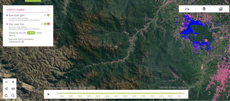
Where deforestation is widespread, sometimes it’s hard to see the (loss of) forest for the (loss of) trees. Global Forest Watch’s online forest change monitoring platform has added a new…
Do you know where your endangered species are? A new online tool offers access to and analyses of a wealth of documents and data related to the United States Endangered…
A satellite-based alert system can now detect fine-scale deforestation in near-real time, enabling managers or rangers in tropical forests to respond to early stages of deforestation. Anyone can now register…
A pair of drones and the efforts of nearly 3,000 volunteers have helped scientists carry out a detailed study of the trees within a 400-hectare (1,000-acre) patch of the Amazon,…
A conservation technology team at WWF-UK has produced a series of best-practice guidelines for three key data collection techniques—camera trapping, passive acoustic monitoring, and remote sensing through Light Detection and…
Can technology drive conservation? That was the question Mongabay founder Rhett Butler recently posed to a panel of three specialists on the frontlines of applying technology to conserve key species…
The agency responsible for looking after the Philippines’ fish stocks has pledged to step up the science behind its management of the resource as it announced new reforms to the…
Taxonomy goes online in the 21st century Charles Darwin’s theory of evolution by natural selection was developed in large part from the observations and collections of plants, animals and fossils…
A multi-national research team combined four diverse data sets to understand where migratory birds are most vulnerable to human activity and to identify priorities for protecting long-distance migrants in the…
Just as humans and many terrestrial animals do, marine creatures use sound for communication in breeding, feeding, social structure maintenance and survival. However, the sounds produced by marine species have…
How many species are living on Earth at this moment in time? Ask a few different scientists and you may get drastically different answers. Most estimates range from 3-10 million…
The United States alone has over four million miles of roadways, according to the Federal Highway Administration (FHA). Wildlife is threatened along every mile of this road network, as well…
As technology for data analysis and visualization improves, online gaming could turn out to be a valuable tool for conservation education, advocacy, and funding. Its role in promoting positive change…
Why track wild animals? How do wildlife biologists know where animals go and the resources they use? They watch them over sometimes extended periods. For millennia, people have watched animals…
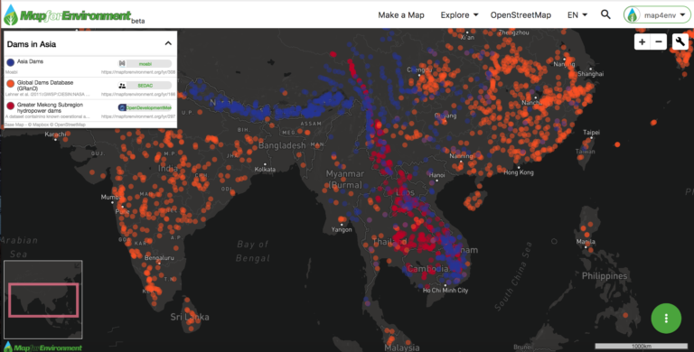
Map for Environment is a free online open-source mapping platform that offers spatial data, tools, and hosting to encourage a wider environmental community to produce maps and increase transparency in decision-making.
A small NGO, Species360, manages a database that stores records on thousands of species around the world, with countless potential applications.
Global Forest Watch analysis tools allow users without a GIS to assess forest loss or gain for countries, parks, or other areas.
Swimming 4 meters per second, a feeding blue whale swings open its jaws and, in four seconds, swallows 140 percent of its mass—a volume of water and krill the size…
An innovative monitoring system analyzes satellite imagery to pinpoint illegal logging in the habitat of the Amur tiger and leopard.
Piezoelectricity has nothing do with pie. In fact, it’s a pioneering avenue of research into producing energy from physical movement, which could revolutionize the way we track fish. By harnessing…
Automated acoustic monitoring of animal sounds can help assess faunal communities and detect endangered species.
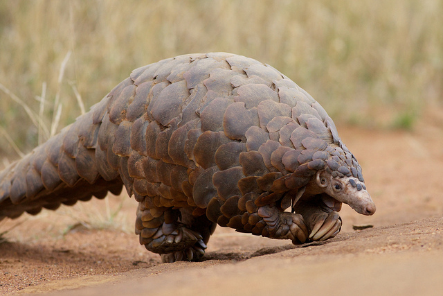
Remember that endangered anteater-esque ball of scales from Favreau’s recent film, The Jungle Book? That’s the pangolin, the world’s most trafficked mammal. Over one million pangolins have likely been poached…