Up in the cool Mexican mountains, countless monarch butterflies gather together for the winter. When the sun warms their wings to just the right temperature, the mass of monarchs take…
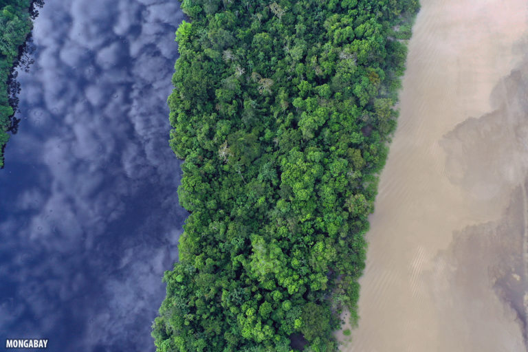
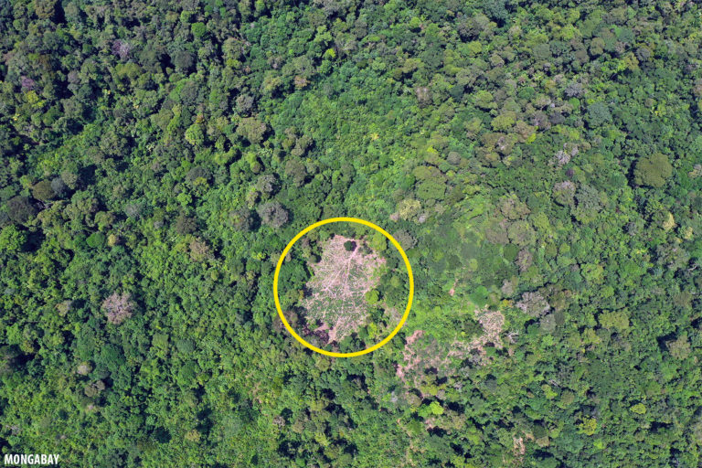
In March 2020, just prior to COVID-19 being a pandemic, I spent a few days in the tri-border region of Brazil, Colombia, and Peru. There I used a drone to…
In early March 2020, I visited the tri-border area of Peru, Colombia, and Brazil and used the opportunity to explore a cluster of potential deforestation hotspots detected by Global Forest…
While I've written about use of drones in conservation since 2012 — a Mongabay story was the first to use the term "conservation drones" — 2019 was the first year…
The dry forest of western Madagascar is famous for its wildlife and baobab trees, including the tourist destinations of Baobab Alley, Tsingy de Bemaraha, and Kirindy Forest. Among the species…
In 2007, the World Wide Fund for Nature (WWF) launched the Heart of Borneo, an initiative that aimed to conserve 22 million hectares (54 million acres) in the transboundary area…
Borneo has been special to me since my earliest years. As a kid, I would voraciously read books about the wilds of Borneo, with its dense rainforests inhabited by traditional…
Sometimes looking for rare plants can mean taking extreme steps. And for decades, botanists at the National Tropical Botanical Garden (NTBG), a nonprofit based on the island of Kauaʻi in…
This story was produced in partnership with the Pulitzer Center. DARIÉN GAP, Panama — There is a land at the center of the Americas that is said to remain in…
Forest monitoring has experienced a revolution in recent years, with vast improvements in satellite sensors, the emergence of drones, and growing ubiquity of on-the-ground technologies like smartphones and camera traps.…
The Brazilian government used a drone to help confirm the presence of an uncontacted indigenous group deep in the Amazon rainforest. FUNAI, Brazil's indigenous affairs agency, undertook an expedition to…
On this episode of the podcast we discuss the increasing use of drones by wildlife lovers, researchers, and businesses, how that might be stressing animals out, and how drone hobbyists…
Last month, Seattle Audubon hosted a panel discussion featuring Mongabay staff and colleagues about the ever-growing applications of technology for conservation. Mongabay Founder and CEO Rhett A. Butler moderated the…
Scientists have discovered a 'supercolony' of Adélie penguins in Antarctica's remote Danger Islands, raising hopes that the bird's population isn't declining as rapidly as previously thought. The discovery, which is…
Steven Kotler is a leading thinker on how technology can be employed to halt the global loss of biodiversity. Recently the prolific author and journalist convened a weekend forum for…
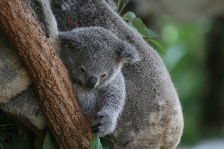
In recent years, unmanned aerial vehicles (UAVs) have increasingly been used to monitor wildlife populations from above, but artificial intelligence has taken drone technology one step further. Koala populations are…
YANGON, Myanmar – Conservation work in Myanmar has been met with various challenges such as limited funding, an unstable political situation and poor management plans for forest reserves. Now, a…
A new study finds that small unmanned aerial vehicles — also known as UAVs or drones — can help reduce the kinds of human-wildlife conflict that often lead to the…
Want to make a million dollars? Find the most efficient way to map Indonesia’s peatlands. That’s the ticket to winning the Indonesian Peat Prize, announced by the cartographically challenged Southeast…
n December 12, 2015 representatives from 196 nations approved the Paris Agreement to address the challenges of climate change. Proponents praised the agreement as a long-term pathway to curbing global…
A collaborative effort in the American West is using Unmanned Aerial Systems (UAS, or drones) to map and evaluate prairie dog habitat for black-footed ferret restoration.
Greenpeace has released dramatic drone video footage showing burning forests and smoldering peatlands in Borneo. The video shows fires burning on peatlands, rainforests, and oil palm plantations surrounding Gunung Palung…
With fire-driven haze casting a pall over Indonesia, Malaysia, and Singapore, the palm oil industry is facing intense pressure to clean up its act. While most big companies have adopted…
by 17 September 2015
The Conservation Drones Summit hosted by the California Academy of Sciences is being streamed live on Periscope by Bryson Voirin. You can watch here. You can also follow the event…
A security expert explains drones for different conservation missions.
Simple, automated speaker systems can help keep elephants out of agricultural areas Elephants in Namibia. The search for effective measures to reduce human-elephant conflict is a top priority for wildlife…
Modern day signs of human activity in the Amazon rainforest. Courtesy of NASA. Click to enlarge. Researchers are planning to use drones equipped with vegetation-penetrating lasers to scan the Amazon…
Altamira municipality. Courtesy of Google Earth. Brazilian municipalities are planning to use drones to map properties and monitor forest cover as they move to step up enforcement of the country's…
One of the coolest endeavors I've come across in recent years of reporting has been the effort to develop "conservation drones" — model aircraft that are now being used to…
Drones have been getting a bad rap lately and for good reason. However in the state of Assam, these commonly used weapons of warfare are being used to monitor the…